Still riding Blue
Creek Rail -- over 50 years later
Many campers in the 50s rode
to and from the Union Carbide summer camps Camelot and Carlisle on Blue
Creek by train. The route ran from Charleston's New York Central station
up Elk River to Blue Creek and then into the woods, eventually stopping
just as the tracks headed south over Blue Creek. Campers then hiked upstream
to Carlisle and then Camelot.
Jim O'Dell of Charleston
sent some fascinating words and video links which show that even though
the camps and the coal mines no longer use the rails, there is still activity
up there:
Clickety clack!....listen
to the horn!
The last time I rode a train
on Blue Creek was coming home from Union Carbide's Camp Camelot in 1952
(58 years ago). A short section of rail is still in usable condition near
the O'Dell property on Blue Creek.
My 1st cousin Frank O'Dell
lives just below the "Big Tunnel" above Quick. The ride was from "Big Tunnel"
to Frank's old home place on Blue Creek. They cut the trees and sprouts
out of the railroad track. The YouTube videos below show the result. Turn
on the speakers! (The "Ken" in the videos is Delmer O'Dell's grandson;
Delmer is Frank's older brother.)
http://www.youtube.com/watch?v=xWuiX1_LcbY
http://www.youtube.com/watch?v=xWuiX1_LcbY&NR=1
Ken purchased the Motor Car
"play toy" from the internet and hauled it inside a trailer from his Indiana
home to WV. Delmer, in poor health, had told Ken that he wanted to ride
the rails on Blue Creek one more time. Ken added an air compressor,
air tank, and a real train air horn...you can see it on the front of the
Motor Car. It will blow the wax out of your ears! You should have heard
the train horn in the tunnel with no top and a small wind screen.
We rode through the tunnel to the far end and reversed and rode about a
mile down stream just above the ball diamond at Quick. The tracks
were abandoned years ago and some sections have been scrapped. They
have pulled the rails and ties in several places. A flood washed
out the trestle at Sanderson (upstream).
Note: Google Maps products
appear below, and they are copyrighted by Google and others.
Please visit www.Google.com
for more map products covering the areas shown here.
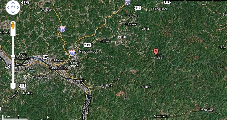
See above. The rail line
followed the Elk River northeast out of Charleston, and then turned east
up Blue Creek to Quick (pointer "A")
From Quick, the rails travel
to Sanderson, at one time a major coal-loading siteto fuel Union Carbide's
powerhouses.
Note the former deep-mine
site just below the "Sanderson" label, just one of many in the area. The
road from Sanderson to the east
eventually passes through
both former Carlisle and Camelot camp sites, and on further to Camp Joshua
Scott, formerly Galahad.
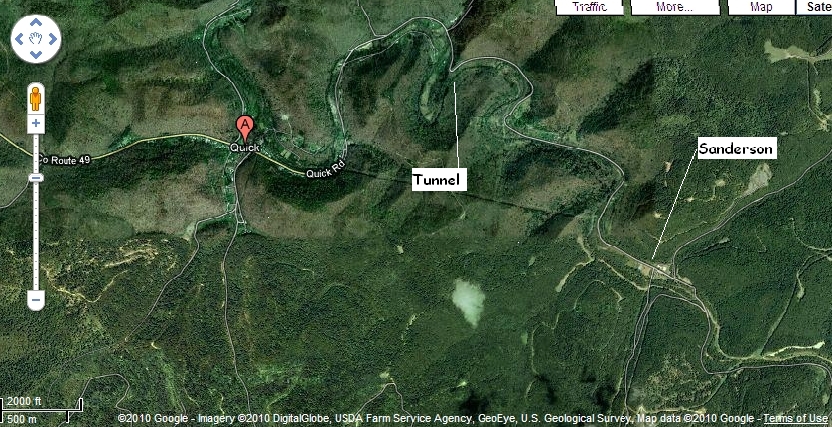
In the picture above, you
see the trestle crossing Blue Creek, and then about 75yds to the right
is the "Big Tunnel" which I estimate to be 100yds in length. You can also
see the remains of the railbed at the east end of the tunnel. the tunnel
was renovated in the 1940s with concrete and brick. The third structure
from your left to right is Frank O'Dell's home. He built the entire
O'Dell Road with his bulldozer several years ago.
Just to the left of the trestle
on the South side, NYC Railroad (later to become Penn Central) remodeled
a box car. They placed it on wooden posts, installed pot belly stove,
door & windows. The students caught the train to attend Elkview
High School. The boxcar disappeared years ago. You could walk
to the side of the line anywhere and hold up your arm and the train would
stop to pick you up. Jack Dawson was the train engineer and everyone
on Blue Creek all the way to Charleston knew him. He tossed candy
and gum to the kids and waved to everyone. He would toot the whistle
for you sometimes. When I was a kid my Dad and I were fishing off
this trestle and a motor car came down the track and stopped. Dad
and the driver were good friends and he gave us a ride upstream to a better
fishing hole. Prior to his quitting time he returned and gave us
a ride back to our car.
The house with the red roof
on the left is at the end of the usable track. It is covered with
a few inches of earth beyond that point. The track we rode is approximately
a mile in length. Trees, saplings, earth, and rocks were removed
to make this section usable. Usually the trestles are overgrown but
I think that Frank kept this one clean as a secondary entrance to Quick
Road. I know of at least six generations of O'Dells in this area.
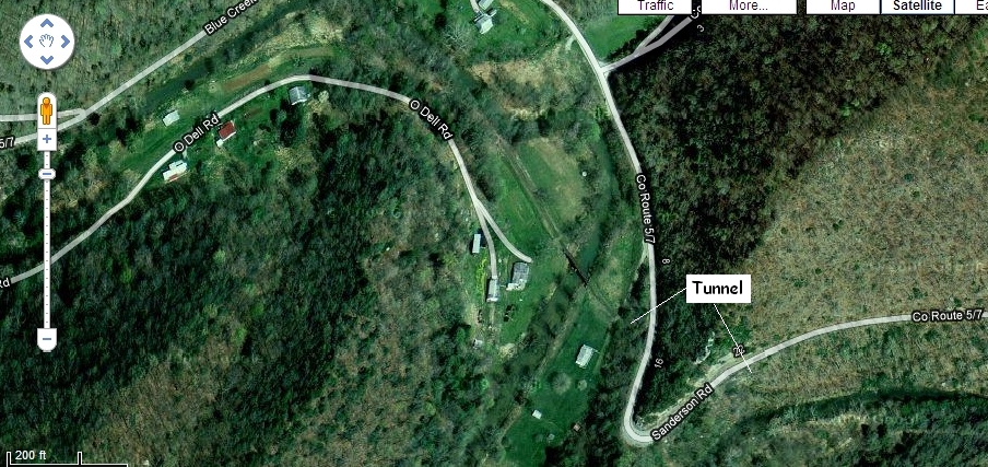
A second picture of the tunnel
and O'Dell property area, with less foliage. The rail roadbed can be seen
emerging from the east end of the tunnel
just beyond the Sanderson
Rd. label to the lower right in the picture. It appears the rails are covered
or may have been removed toward the east.

Evidence of old rail lines
is scant east of Middle Fork, where the rails turn south toward Kendalia,
just to the left of this picture..
The road from Sanderson
continues to the camps sites and further upstream to the former Carbide
Hunting and Fishing Lodge, now residential.