|
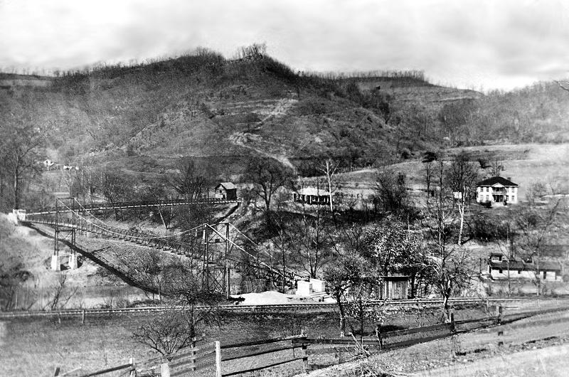
(The Clilffside site is just out of the picture a short distance to the right.) See http://www.mywvhome.com/old/bridges.html, and the rest of the mywvhome.com page! Some absolutely GREAT panoramic shots of Charleston and South Charleston! Thanks, Jerry. "This rare photo circa 1921 is very interesting to me.If you look very closely, you can make-out both the Big and Little Coal Rivers near Alum Creek. The two swinging bridges are there to this very day and in relatively good condition. Where they meet (on the left of the photo) is called "The Point", and there used to be a one room school house and several homes. They are long gone now. The school was later built across the river to the right of that big white house on the right. It too is now gone. A most interesting site in this photo is the riverboat in the right hand corner. That boat is dredging sand from the river bottom. Not for navigation, but to harvest sand for re-sale. "( see more below ) This is how "Sand Plant Road" off Corridor G got its name. When you think about how far inland this section of the river is from the Kanawha River, that big boat is pretty amazing. Most of the property you see where the houses are belonged to the Childress's, and much of it still does today. A Childress was on the County Commission that built these bridges also. It's my understanding that the State wanted to keep these bridges in shape, but the new owner of "The Point" didn't want this to happen. That's a shame, because swinging bridges like these are a real treasure and I hate to see them just rust away to nothing." See the swinging bridge page at http://www.carbidecamps.net/Cliffside/DoubleBridgeCliffside/TheDoubleBridge.htm |